General cargo ship · Netherlands flag · built 2025
BALTIC DREAM: CO₂ emissions 2025
IMO 9969522 MMSI 245246000EU ETS
- CO₂ reported 2025
- 873 t
- Fuel burned
- 272 t
- Time at sea
- 2,049 h
- Emitted at berth
- 8% of total
- Share of year under way
- 23%
- Gross tonnage
- 2,728
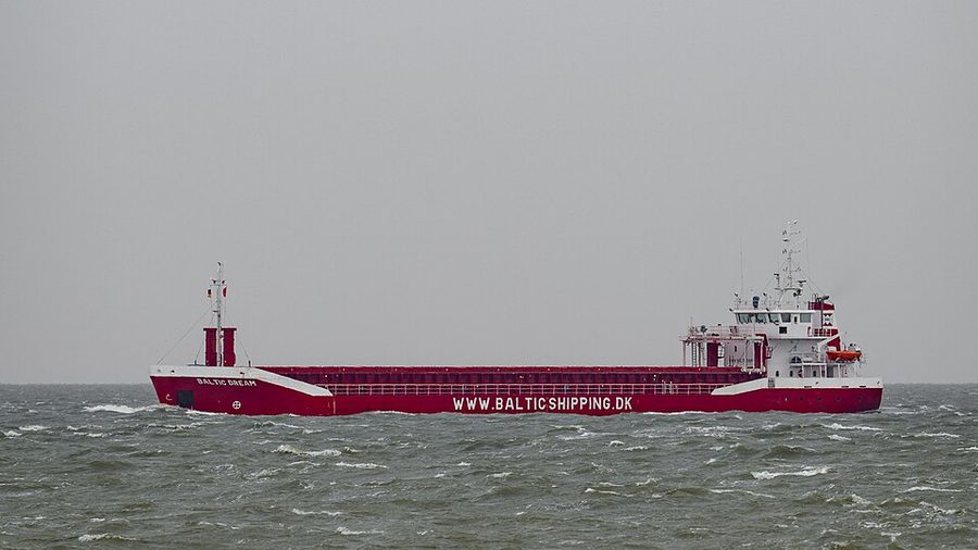

BALTIC DREAM against its type
Built in 2025, it is 18 years newer than the median general cargo ship on this register, which was built in 2007 (2,852 vessels with a known build year). At 2,728 gross tonnage it is smaller than 84% of the other 2,665 general cargo ships with a recorded tonnage. It is one of 306 general cargo ships here under the Netherlands flag, 9.9% of the 3,081 on the register. The same builder is recorded for 1 other vessel here, also a general cargo ship.
Its 873 t of CO₂ for 2025 is 69% below the median of 2,820 t among the 2,469 general cargo ships on this register that reported for 2025. Per nautical mile it emitted 51.4 kg CO₂, 58% below the type median of 122.2 kg. It logged 2,049 hours at sea against a median of 3,044 hours for its type that year. 8.5% of its 2025 emissions were at berth; the median for general cargo ships was 4.3%. The one sister ship listed below with a 2025 return reported a lower CO₂ per nautical mile.
Emissions by year2025–2025
| Year | CO₂ (t) | Fuel (t) | Distance (nm) | At sea (h) | At berth (t) | kg CO₂/nm | EEOI | Percentile |
|---|---|---|---|---|---|---|---|---|
| 2025 | 873 | 272 | — | 2,049 | 74 | 51.4 | — | — |
Vessel particulars
- IMO number
- 9969522
- MMSI
- 245246000
- Call sign
- PDLB
- Ship type
- General cargo ship
- Gross tonnage
- 2,728
- Length overall
- 88.0 m
- Beam
- 13.0 m
- Year built
- 2025
- Flag state
- Netherlands per EU MRV 2025
- Builder
- Ship and Steelbuilding (SaS)
- Port of registry
- GRONINGEN MRV 2025
- Technical efficiency (design)
- EEXI (11.79 gCO₂/t·nm)
- Verifier
- DNV, Germany
- Accreditation
- VS-16026-01
- Compliance document issued
- 2026-01-27
- Compliance document expires
- 2027-06-30
Where the 2025 emissions occurred
Methane, nitrous oxide and EU ETS2025
- Total CO₂ equivalent
- 887 t
- Methane (CH₄)
- 0.01 t
- Nitrous oxide (N₂O)
- 0.05 t
- Under EU ETS
- 820 t, 94% of total
Observed movementsAIS · Norwegian waters
- First seen
- 16 Nov 2025
- Last seen
- 17 Nov 2025
- Days observed
- 2
- Positions
- 89
- Median speed
- 9.5 kn
Its recorded positions span 58.0°N to 58.3°N and 5.9°E to 6.7°E.
24 hourly points from 89 positions. Filled circle first, open circle last; squares are ports for orientation, not calls.
Norwegian Coastal Administration open AIS, Norwegian waters only, 01 Jul 2025 to 27 Jul 2026. A gap means the vessel was not recorded here, not that it was idle or that a transponder was off.
Sources and how to read this
- Emissions: EU MRV publication (THETIS-MRV), reporting years 2025–2025, published by the European Commission.
- Vessel particulars: Wikidata (CC0) and Wikimedia Commons.
- Movements: Norwegian Coastal Administration open AIS extract.
This page draws on 1 MRV reporting year, 5 of 5 vessel particulars, AIS movements in Norwegian waters and a licensed photograph. Not found in the sources for this vessel: an efficiency ranking, a name history, a sanctions listing and US port state inspections.
Empty means unreported, never zero. How EEOI, distance, percentiles and sister ships are handled is explained under reading a vessel page. Something wrong? See corrections.